By Nora Ma
Questions
What does Taipei’s grid represent? How and when did Taipei’s grid develop? Who developed it? How do “ordered” structure, lived experience, and power dynamics interact with one another in a historical setting?
Discussion

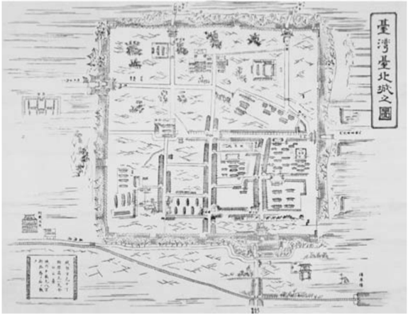
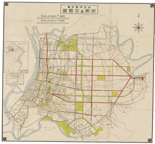
The theoretical approaches of the papers reviewed varied from comparative urban history to a sociological perspective on historical development and change within aspects of Taipei’s existence. However, all of the articles discussed focused on the changes that Japanese colonialism brought to both Taipei and Taiwan. Initially, the grid of Taipei was much less developed and intricate. As cited by Joseph Allen in his book, the SMC publishing map shows a relatively rudimentary grid. However, Allen notes a “railroad line” at the “bottom of the map,” a reflection of Liu Mingchuan, a Qing-period Governor of Taiwan, and the modernizations he attempted to bring (27). Furthermore, Allen indicates that Liu also brought “electrification, schools of Western learning, rickshaws, and other material changes” (27). However, compared to the later maps included by Allen, the urban planning of the Japanese created a more complex grid, filling in for the sparser, rudimentary grid that existed before Japanese arrival; they provide a visualization for Japanese plans, “in which an efficient transportation system joins sites of civic leisure” as “urban modernity displaces the rural economy” (33). These improvements ranged from parks to transportation, creating a city that was more integrated and denser. Although the existing literature in English directly addressing Taipei City’s development and organization of the grid during its time as Taihoku – as it was called during the Japanese era – is sparse, a number of the articles address how colonialism has deeply shaped Taipei, whether it be in terms of changing the way space was understood through the grid or the implicit cultural attachment to Japan that still exists today in the architectural design of structures. The built environment as a product of colonialism is a thread that runs through all of the literature, representing the structural, and in turn, cultural, impression left by Taiwan’s former colonizer.

Figure 2: 1932 Taipei City Plan.
Allen’s discussion of history through mapping and architecture provides broad visualizations of colonialism as well as a discussion of Taipei’s origins before Japanese occupation. His book includes a number of maps and traces how the city itself developed from sparse plots to the detailed grid of streets in the 1930s, providing an overview of development. Allen argues that Japan’s geopolitical prospects and imperial status interrupted and fundamentally changed the lives of local Taiwanese: “The ruler-straight lines, with their 90-degree intersections, suggest that no local accommodations needed to be made in these plans” (33). He suggests that the urban planning of Goto Shimpei, one of the leaders in civilian affairs, emphasized the centrality of colonial presence through both the construction and organization of the city. By deconstructing the Chinese-built city wall, expanding Taipei, and separating districts and neighborhoods by ethnicity, Goto created an “attitude of political inclusion, as illusory and one-sided as it might have been” (33). Allen’s description of inclusion as illusory shows how it was contingent on the gradual development of an assimilation policy by the Japanese (33). Allen also highlights the European design in politically important buildings at the time, allowing Japan to “prove” its modernity in its colony (34) These organizations and architectural styles further the concept of the “ordered,” as implemented by the colonial power, reshaping and redefining space to suit the political needs of the colonizer.
Goto takes a comparative historical lens to Taipei and Seoul. Goto compares the contents and results of the Taipei and Seoul Urban Improvement Programs, then the Planning Orders of Seoul and Taipei, both of which were implemented by the Japanese Empire. The initial Urban Improvement Programs had a number of disparities between Taipei and Seoul, including differences in policy regarding the inclusion of water supply and sewage systems that are part of the Taipei plan (7). Goto’s article emphasizes the parallelism between the later Planning Orders of Seoul and Taipei in the 1930s, showing that the implementation of both was due to Japan’s use of the same underlying structure, allowing for standardization between the colonial cities (9). Both of the Planning Orders were based on Japan’s City Planning Act of 1919. Goto also highlights how a number of the infrastructural pieces of the order continued to be encoded in post-WWII Taipei’s governance plan, simply because of its importance to “the stability of society” and “protection of residents’ interests.” and that it did not contradict the new values of the government (8). These laws that were re-encoded were most likely standard regulatory laws regarding property rights and maintenance of infrastructure. Although Goto did not explain why the Chinese adopted 236 Japanese laws, it can be inferred that these were simply adopted to maintain order and functionality of the city. Goto’s article furthers the role of the “ordered” in this framework; the city’s grid and planning policies became integral to the functionality of the city despite its Japanese origins, leaving a mark of colonial influence (9).
“Walking in Colonial Taiwan: A Study on Modern Urbanization of Taipei” offers a sociological approach to understanding how the reordering of Taipei’s space fundamentally transmuted the relationship between “the colonized,” “the colonizer,” and “the urban form,” creating a disparity in the perception of the built environment (Wu, 311). It starts with a brief historical background of the grid’s development, including the introduction of the “block” to Taipei, the creation of new networks between roads, and the establishment of the Japanese Governor-General’s home in front of New Taipei Park as part of the Great Taipei City Plan of 1932. Wu introduced the colonized native Taiwanese as a “flaneur” from Walter Benjamin’s conception of a stroller who observes (308). Through the newly reformed Japanese Taipei, Wu evokes the dissonance between the colonizer and the colonized through written accounts of the time highlighting the Japanese-imported, Western nature of phenomena like department stores or the newly constructed grid form (312-313). Wu argues that these foreign structures, which created “colonial modernity” through mapped grids, architectural forms, and the implementation of consumerist habits imbued in the built environment, allowed Japanese colonizers to “beautify or fantasize urban images,” in contrast to the differences between the foreign and familiar discerned by Taiwanese (314). Despite the “order” behind the grid, the structural changes implemented by the Japanese created a dissonance for native Taiwanese. This specific source provided written evidence of how Taiwanese felt about the changes that defined their experience, whereas other articles in this literature review did not provide substantiating evidence.
Wu and Lay’s article on the mapping and restructuring of water estates in Taiwan furthers the concept of an interruption of cultural history, even though it is primarily an evaluation of mapping history. Irrigation systems, another form of infrastructure, were transformed by the Japanese from a culturally significant private enterprise to a local public system. The forced extensive mapping of previously private irrigation systems was less unsettling than forcing a grid onto Taipei. The new Japanese system allowed Taiwanese control of local irrigation development and provided jobs in surveying, while a central Japanese-driven accountability system recorded the local irrigation systems. This “order” had a different impact on colonial relations; unlike the disconcerting application of the grid onto Taipei, “multiple faces of the development of colonial irrigation mapping in Taiwan were supported by the demands of both the ruling power and civil society” (106). Wu and Lay briefly mention the influence that the change in water management had on local society, but this point could have been further explored through their mapping analysis.
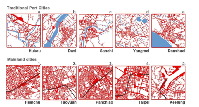
The final structure explored in the literature demonstrated how railways compressed space and changed local society in Taiwan. Applying a Marxist lens to transportation, Huang and Kuo argue that the railroad, as a structure, disturbed how distance operated and changed the ways periphery communities were developed. Incorporating the “space-time” compression theory of geographer David Harvey, they state that economic development borne out of capitalism and imperialism fostered the destruction of Chinese government buildings and temples in order to lay rail (90). Showing the increasing number of rail connections to inland cities and decreasing significance of port cities, they further contend that the intrusion of this form of structural order led to unfamiliarity for Taiwanese and loss of a “sense of place,” often rooted in localism (93). In addition to the

establishment of railways, which minimized distance for economic development, the Japanese also built new institutions, such as schools, banks, and colonial administration, which introduced an expansion of spatial power. Symbolically, buildings were able to serve a political purpose, showing the dominance and preeminence of Japanese rule. This study, while theoretically important and complex, could have benefited from direct examination of Taiwanese response to these changes as well.
While the approaches of each journal article, book, or conference paper were different, they all focused on one idea: disruption of the existing social or cultural tradition through changes in the built environment under colonial rule. Although many of these structures, including railways, the gridded city, or stylistically consistent architecture, are all “ordered” in some way, the literature shows how Japanese implementation of these practices changed occupied space and the meanings of the colonized and the colonizer, influencing the common understanding of Taipei today.
Sources
Goto, Yasushi. Comparative Study about the City Planning Systems in Taiwan (for the Years 1895–1945) and Korea (for the Years 1912–1945) under Japanese Rule. 2018, https://journals.open.tudelft.nl/index.php/iphs/article/download/2674/2883/
Huang, Po Ju, and Chaolee Kuo. Front and Back of Taipei Railway Stations: Modernity, Hybridity and Diaspora of the Postcolonial City. Queensland University of Technology (QUT), 2013, pp. 86–95, https://eprints.qut.edu.au/80192/1/ISUF_Papers_Master_Document_Final.pdf
Allen, Joseph R. “Mapping the City.” Taipei: City of Displacements, University of Washington Press, 2012. JSTOR, JSTOR, https://www.jstor.org/stable/j.ctvcwn62d.
Wu, Chia-Jung, and Jinn-Guey Lay. “Beyond Technology: Japanese Colonial Mapping of Water Estates in Taiwan from 1901 to 1921.” International Journal of Cartography, vol. 1, no. 1, May 2015, pp. 94–107.
Wu, Ping-Sheng. “Walking in Colonial Taiwan: A Study on Urban Modernization of Taipei, 1895-1945.” Journal of Asian Architecture and Building Engineering, vol. 9, no. 2, Oct. 2018, pp. 307–14.

